
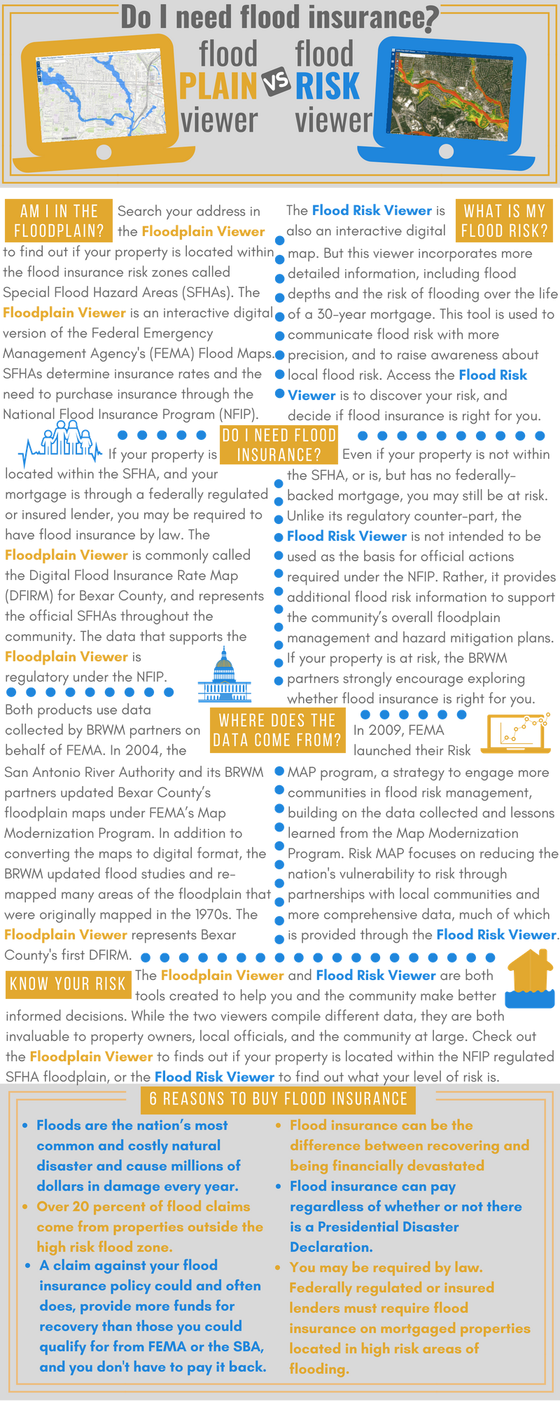
Are you in the floodplain?
Search your address to find out if you are in the Floodplain.
If your property is located within the flood insurance risk zones (Special Flood Hazard Areas or SFHAs), and is mortgaged through a federally regulated or insured lender, you may be required to have flood insurance by law. Search your address in the San Antonio River Authority’s Floodplain Viewer to find out if your property is located within an SFHA.
The Floodplain Viewer engages users in an interactive map, displaying the Federal Emergency Management Agency’s (FEMA) National Flood Hazard Layer (NFHL) data. Together with its many Bexar Regional Watershed Management (BRWM) partners, the San Antonio River Authority collected the data used in the digital maps, providing basic information about the floodplains in Bexar County (also includes data for Wilson, Karnes, and Goliad Counties).
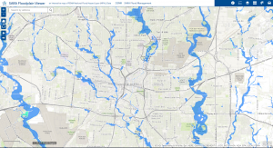
Click image to search your address in the Floodplain Viewer
What is your food risk?
Search your address to find out more about your flood risk.
Even if your property is not in the floodplain, you could be at high risk of flooding. The San Antonio River Authority’s Flood Risk Viewer compiles layers of data acquired through FEMA’s Risk MAP program. Search your address for a more complete analysis of your flood risk. The Flood Risk Viewer provides flood depth data for the 1 percent annual chance flood and data on the risk of flooding over the life of a 30 year mortgage. Discover your risk below.
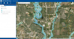
Click image to search your address in the Flood Risk Viewer
Know Your Risk
Know Your Risk
Risk Mapping, Assessment, and Planning (Risk MAP) is a Federal Emergency Management Agency (FEMA) program that provides communities with updated flood hazard information and risk assessment tools they can use to enhance their mitigation plans to better protect their citizens. Through more accurate flood maps, risk assessment tools, and outreach support, Risk MAP strengthens local ability to make informed decisions about reducing flood risk. Risk MAP uses a watershed-based study approach which improves engineering credibility and allows for the understanding of risks in a more comprehensive way. Risk MAP products are non-regulatory and do not directly modify flood insurance rates as determined by existing Flood Insurance Rate Maps (FIRMs).
Risk MAP Project Areas
Risk MAP Project Areas
Projects are underway in each of the four major watersheds in the San Antonio River Basin. These are the Upper San Antonio River, the Medina River, Cibolo Creek, and Lower San Antonio River. Each project includes three phases: “Discovery,” “Risk Identification and Assessment,” and “Regulatory Product Update.” These projects are supported by a combination of FEMA grant funding and SARA local match dollars and in-kind services.
| Discovery | Risk Identification and Assessment | Regulatory Product Update | |
| Upper San Antonio River | Completed 2013 | Initiated 2012 (ongoing) | TBD |
| Medina River | Completed 2015 | Initiated 2015 (ongoing) | TBD |
| Cibolo Creek | Initiated 2015 (ongoing) | Begins 2017 | TBD |
| Lower San Antonio River | Completed 2016 | Begins 2017 | TBD |
Upper San Antonio River Watershed

The Upper San Antonio study area is approximately 507 square miles and is comprised of 2 major sub-watersheds, the Upper San Antonio River Watershed and the Salado Creek Watershed. Both of these major sub-watersheds are predominately located within Bexar County. This Risk MAP project will seek to leverage previously developed DFIRM hydraulic models and 2009/2010 LiDAR data to produce additional flood depth and flood risk data products for approximately 250 stream miles.
Medina River Watershed

The Medina River study area is approximately 1,348 square miles and is comprised of 2 major sub-watersheds, the Medina River Watershed and the Leon Creek Watershed. This study area extends from Bandera County down into Bexar County where it confluences with the San Antonio River. This Risk MAP project will leverage previously developed DFIRM hydraulic models, 2009/2010 LiDAR data, and 2013 LiDAR data to produce additional flood risk data products for an estimated 350 stream miles.
Cibolo Creek Watershed

The Cibolo Creek study area is approximately 854 square miles. This study area extends from Kendall County down into Karnes County where it confluences with the San Antonio River. This Risk MAP project is finalizing the Discovery phase, and areas are being selected for Risk Assessment and Identification.
Lower San Antonio Watershed

The Lower San Antonio Watershed study area is approximately 1,485 square miles and covers portions of Bexar, Calhoun, DeWitt, Goliad, Guadalupe, Karnes, Refugio, Victoria, and Wilson Counties. This Risk MAP project is finalizing the Discovery phase, and areas are being selected for Risk Assessment and Identification.
Risk MAP Data Products
Risk MAP Data Products
The Risk MAP project will produce several key deliverables regarding flood risk within the study watershed. The data products produced in a Risk MAP project do not necessarily seek to replace any DFIRM products but rather enhance a community’s awareness of flood risk through the creation of products listed below.
- Flood Risk Report
- The Flood Risk Report (FRR) will present key risk analysis data for the study watershed. The objective of this watershed report is to provide the community with a summary of the flood analysis and results that have been conducted within the study watershed.
- Flood Risk Map
- The Flood Risk Map (FRM) will provide a graphical overview of the project area. The objective of the FRM is to summarize the notable flood risks within the study area and present these data within one large map.
- Flood Risk Database
- The Flood Risk Database (FRD) is designed to store all of the final Flood Risk Datasets used in to create and support the FRR and FRM. This data product is delivered in a digital GIS format and is intended for stakeholders to leverage with their own GIS platforms.
Flood Risk Datasets
Flood Risk Datasets
This data products transcend traditional regulatory floodplain data products and seek to assist in conveying flood risk in terms of both severity and magnitude. These products can assist in analyzing and communicating flood risk within each project area. More information regarding Flood Risk Products can be found here.
Flood Depth & Analysis Grids
This data will provide information that will allow users to understand flood risk by visualizing flood depths, flood water surface elevations, interpolated annual chance risk, and percent 30-year chance flood hazards. The table below provides more specific information regarding these enhanced non-regulatory data products. The table below outlines and describe some of the Flood Risk Products that are being produced around the nation. Note that development of these products may vary between project watersheds.
| Product | Description |
| Water surface elevation grids | Representations of the modeled water surface elevation for various flood frequencies, primarily the 10%, 4%, 2%, 1% and 0.2% annual chance flood events. |
| Flood depth grids | Representations of the flood water depths for various flood frequencies; primarily the 10%, 4%, 2%, 1% and 0.2% annual chance flood events. |
| Water surface elevation change grids | Representations of the difference between the effective and revised 1% annual chance floodplain water surface elevations for areas that were both SFHA before the revision and after the revision. |
| Velocity grids | Representations of the flood velocity distribution created by mapping the velocity output data using FEMA accepted hydraulic models |
| Percent annual chance grids | Representations of the percent-annual-chance of flooding for discrete locations within the extent of the mapped flooding source. |
| Percent 30-year chance grids | Representation of the percent chance of a discrete location experiencing flooding at least one time during a 30-year period. This dataset is developed for all locations within the mapped floodplain. |
| 1% plus flood elevation grids | Representations of the upper statistical confidence limit flood elevations for the 1% annual chance flood event. |
Depth Grids
Flood Risk Assessments
This dataset will be comprised of several analysis results that help to better assess the potential losses from a flood event. The intended use of these data will be to identify areas and communicate flood risk, provide potential monetary losses due to a flood, and improve loss estimations by incorporating local data into more enhance future analysis.
Changes Since Last FIRM (CSLF)
This dataset compares previously effective flood hazards (Flood Insurance Rate Maps or FIRMs) with newly proposed mapping. The data will categorize and quantify the change in the two flood hazards. The objective of this dataset is to communicate proposed changes to the flood hazard as well as provide useful information as to the reason behind the change.
Areas of Mitigation Interest
The Areas of Mitigation Interest (AoMI) dataset is intended to communicate areas and issues associated with flood risk reduction opportunities and/or success stories. This dataset allows local stakeholders to provide information about local mitigation successes and gain a more holistic picture of flood risk related issues that may impact them, as well as allowing them to take a more systematic approach to addressing their community’s overall flood risk.
Cooperating Technical Partners (CTP)
Cooperating Technical Partners (CTP)
The San Antonio River Authority (SARA) and the Federal Emergency Management Agency (FEMA) have developed a successful partnership towards the common goal of reducing flood risk. As a Cooperating Technical Partner (CTP), SARA works with local communities to implement FEMA programs and to incorporate local knowledge and data into flood hazard mapping and mitigation planning. SARA has been a CTP with FEMA Region VI since 2003, during the “Map Modernization” program which converted paper Flood Insurance Rate Maps to Digital Flood Insurance Rate Maps. During the “Map Modernization” program SARA invested $14 million to comprehensively map over 1,700 stream miles in Bexar County using up-to-date topography, land use, impervious cover and rain fall data to update Bexar County’s decades old flood maps. Currently, SARA acts as a Letter of Map Revision (LOMR) Review Partner and manages Risk MAP projects for the watersheds in the San Antonio River Basin.